
English| EUR
Suggested for you
More currencies
Choose a language
The Ha Giang Loop circles 300 kilometers through northern Vietnam's most remote mountain terrain, crossing eight passes above 1,000 meters and threading through valleys where Hmong, Tay, and Dao communities maintain centuries-old traditions. Foreign visitors require a regional travel permit issued in Ha Giang city before departing. This guide covers the logistical foundations, route decisions, and on-road realities that shape a successful loop.
Quick answer
The Ha Giang Loop requires a regional travel permit for foreign visitors, arranged through guesthouses or tour operators in Ha Giang city within one business day. The 300-kilometer circuit typically spans three to four days, following the QL4C highway through Quan Ba, Yen Minh, Dong Van, Meo Vac, and back via Du Gia. Most riders depart between 08:00 and 09:00 to complete each 70–100 kilometer segment before sunset, as unlit mountain roads become hazardous after dark.
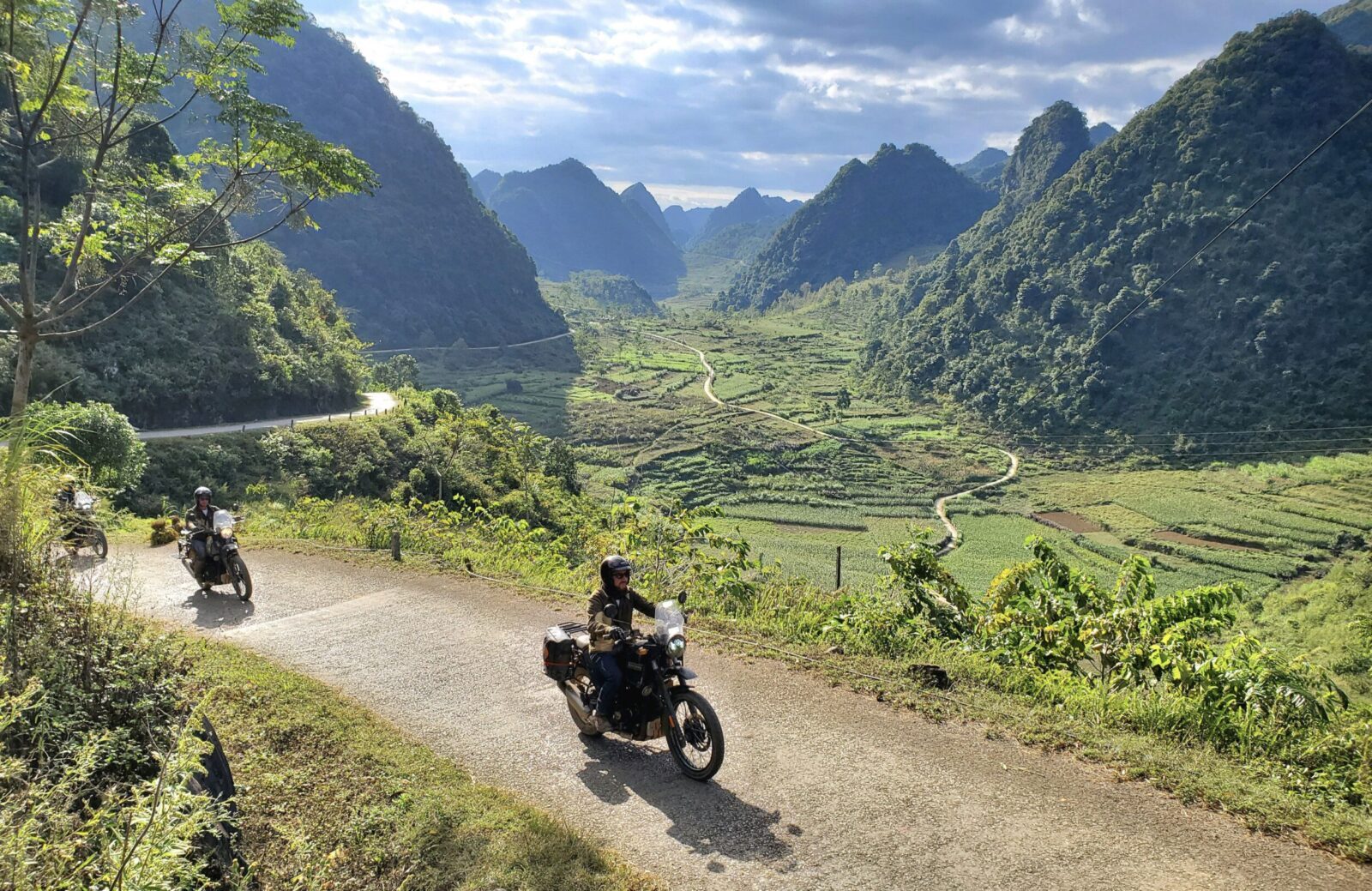
Sixty-three hairpin turns climb the Ma Pi Leng Pass, each corner suspended above the Nho Que River canyon 1,200 meters below. The Ha Giang Loop has transformed from a supply route connecting border garrisons into Vietnam's most-discussed self-drive motorbike route, drawing 40,000 foreign visitors annually to Ha Giang Province's karst peaks and ethnic minority villages. The loop's clockwise direction—Quan Ba to Yen Minh to Dong Van to Meo Vac—follows the safest traffic pattern, keeping riders on the inner lane during descents on narrow two-lane roads where trucks and buses claim the right of way. Counterclockwise riders face oncoming traffic on blind corners where asphalt gives way to gravel and road edges crumble into unguarded drops. Most guesthouses stock route maps marking police checkpoints at Tam Son, Lung Cu junction, and the Meo Vac town entrance, where officers verify permits and occasionally issue warnings about road conditions ahead. Motorbike selection separates manageable days from exhausting ones. Semi-automatic Honda Waves dominate rental fleets because their 110cc engines handle steep grades without overheating and their light frames recover easily from gravel slides. Manual bikes offer more control on long descents but require constant clutch work through villages where children, chickens, and water buffalo share the road. Riders without multi-day manual experience choose semi-automatics. Brake pads wear thin on extended downhill sections—mechanics in Dong Van and Meo Vac replace them while you drink coffee, usually within thirty minutes. Fog banks settle into valleys between 06:00 and 09:00 during cooler months, reducing visibility to five meters on passes above 1,400 meters. Afternoon rains between May and September turn dust to mud on unsealed sections near Du Gia, where the loop rejoins Highway 2. Navigation advice for the Ha Giang mountain circuit emphasizes early starts, conservative speed on descents, and overnight stops that align with the road's natural segments rather than arbitrary daily distance targets. The loop's reputation rests on its combination of technical riding, geographic drama, and cultural immersion—completing it safely requires matching your skill level to the road's demands and your daily distance to realistic riding hours.
“The loop's clockwise direction keeps riders on the inner lane during descents on narrow roads where trucks claim the right of way.”
The most favorable time to visit Ha Giang is during the dry season, specifically from September to November or March to May. These periods offer stable weather conditions and clear visibility for navigating high-altitude mountain passes.
Cool, dry; 15°C to 25°C
This period features golden rice terraces and mild temperatures. It is widely considered the prime window for photography and comfortable riding.
Warm, pleasant; 18°C to 28°C
Spring brings blooming flowers and moderate humidity. Roads are generally dry, making it safer for motorcycle travel.
Hot, rainy; 22°C to 32°C
Expect frequent rainfall and potential mud on mountain roads. Careful planning is required due to unpredictable weather patterns.
Cold, foggy; 5°C to 15°C
Temperatures drop significantly, and thick fog often reduces visibility on mountain passes. Travel during these months requires heavy cold-weather gear.
Verdict: The optimal time for a Ha Giang Loop tour is mid-October or April, prioritizing the arrival window of 08:00–16:00 to ensure navigation during daylight hours.
Ha Giang Province is located in Northern Vietnam, typically accessed from Hanoi via the highway network connecting to the city of Ha Giang. Most travelers utilize long-distance bus services or private car transfers to reach the region.
Hanoi My Dinh Station to Ha Giang City via QL2
Private transfer via Noi Bai–Lao Cai Expressway and QL279
Hanoi Gia Lam Station to Ha Giang City via QL3 and QL279
The best arrival window is 08:00–16:00 to ensure optimal daylight for mountain pass navigation and to avoid peak traffic hours. Upon arrival at the Ha Giang terminal, visitors should ensure they have secured the necessary regional travel permit.
Access to the Ha Giang loop region does not require a standard entrance ticket. Visitors are only required to obtain a mandatory regional travel permit.
Verdict: While the loop has no entrance fee, the total cost for access is determined by the required regional travel permit fee.
Many riders underestimate the Ha Giang Loop's technical demands and weather volatility. Avoiding these planning and safety errors ensures a safer, more manageable journey through the northern mountains.
Starting the loop without a valid travel permit
Foreign visitors must obtain a regional travel permit before departure. Secure it through your accommodation or a local agency at least one day in advance to avoid roadside fines or route restrictions.
Underestimating mountain pass difficulty and riding experience
The loop includes steep, narrow passes with sharp switchbacks and loose gravel. Riders with limited motorbike experience should consider hiring an experienced driver or joining a guided convoy for safer navigation.
Ignoring sudden weather shifts in high-altitude areas
Mountain weather changes rapidly, with fog and rain reducing visibility within minutes. Pack waterproof gear, check forecasts before each day's ride, and delay departure if conditions deteriorate to avoid dangerous road surfaces.
Riding during low-light hours on unlit mountain roads
Most passes lack street lighting and have blind corners. Plan your daily route to arrive at destinations between 08:00–16:00, giving a safety buffer before sunset and reducing collision risk with livestock or oncoming traffic.
Skipping vehicle condition checks before multi-day rides
Brake failure or tire blowouts on remote passes create serious hazards. Inspect brakes, tires, lights, and fuel levels each morning, and carry a basic repair kit since roadside assistance is limited in rural areas.
Foreign visitors require specific documentation and gear to navigate the mountain terrain safely.
Navigating the Ha Giang region requires specific attention to local road conditions and cultural etiquette to ensure a respectful and manageable journey.
Use low gears to control speed on steep mountain passes instead of relying solely on your brakes. This prevents brake fade during long descents common throughout the region.
Sound your horn proactively when approaching sharp, blind curves to alert oncoming trucks or motorbikes. Drivers in these mountains often hug the center line to avoid shoulder debris.
Ask for permission before photographing residents or entering private village homes. Small gestures, such as accepting tea when offered, facilitate better rapport in ethnic minority communities.
Keep your fuel tank at least half full at all times, as gas stations are infrequent in remote sections. Relying on bottled gasoline from roadside kiosks is a fallback option but rarely provides high-quality fuel.
Expect gravel, livestock, or falling rocks on the tarmac after rainfall. Maintain a wide following distance behind local transport vehicles to react to sudden stops or obstacles.
Everything you need to know about ha giang loop tour tips
Foreign visitors must obtain a regional travel permit to legally traverse the area. You can typically arrange this through your hotel or at the local immigration office in Ha Giang City.
Following ha giang loop tour tips, you should aim to arrive between 08:00 and 16:00. This optimal daylight window ensures safer navigation of the winding mountain passes and helps you avoid peak traffic hours.
Using an experienced local guide is highly recommended for navigation and cultural context. These experts help manage challenging road conditions while sharing insights into the local ethnic minority villages and karst landscapes.
Prioritize wearing a high-quality helmet and protective gear at all times on the road. Following these ha giang loop tour tips also means maintaining a moderate speed and checking your motorcycle's brakes and tires before departure each day.
There is no specific entrance fee for the loop itself, so entry is 0 VND. However, always carry your passport and permit, as officials may request documentation at various checkpoints along the route.
August weather in Northern Vietnam can be unpredictable with occasional rain showers. Pack versatile, waterproof clothing and ensure you have sturdy footwear for exploring the steep mountain terrain comfortably.
Ha Giang Loop Tour Groups
Read more Guide3 Day Ha Giang Loop Itineraries
Read more GuideHa Giang Loop Tour Route Map
Read more GuideHa Giang Loop Tour Gallery
Read more Tickets & toursHa Giang Loop Tours from Hanoi
Read more Tickets & toursHa Giang Loop Tour Companies
Read more Tickets & toursHa Giang Loop Motorbike Tours
Read more GuideHa Giang Loop Tour Price & Cost Guide
Read more GuideBest Time to Do the Ha Giang Loop Tour
Read more